VENICE SUBSTRUCTURE COMPLEX / PHASE II SITE CONCEPTS >> (FOREST SHIP/CISTERN SHIP)
Forest Ship, is a conceptual proposal for a landscape project that extends the conversation of Venice’s Substructure Complex with its environment. The ship is proposed as a sediment filled, allochthonous structure of carbonate rocks (Istrian limestone and Veronese marble among others) with a forest superstructure, voyaging in a sediment sea. The surface area of the ship is 30,000 acres (121 km2) of larch (or related trees) forest planted at 400 trees/acre (400/4046.85 m2) giving a total of 12,000,000 trees, a theoretical average of the number of pilings beneath Venice that was determined by the research in Phase I of this project. This structure completes the aerobic/anaerobic/aerobic (anoxic/oxic/anoxic) cycle of the original forests submerged beneath Venice through a symbolic replanting of those trees as a living forest in the open air. This replanting suggests a conversation between the forest’s original sunlight and atmosphere and that of contemporary conditions.
This invisible forest beneath Venice is preserved by its anoxic environment, displaced geographically and atmospherically from its aerobic origin of local terrain, encased in a sedimentary matrix of complex origin (Mesozoic, Tethys Ocean-derived sediments altered by plate tectonics of the Alpine Orogeny and subsequent glacial processes). The origInal forests were nurtured by nutrient systems of similar Alpine mineral, biological and climatic legacy, embedded in each tree-trunk. Forest Ship’s symbolism and orientation indicated by its vectored orientation to the Alpine orogeny, suggests other paleogeographic/paleoclimatic journeys latent in the landscape created by a much vaster ship of the Auplian/Adriatic plate through the lost Tethys and Pennine Seas of Mesozoic/Cenozoic time.
Cistern Ship is conceptualized as another extension of the Venice Substructure Complex, in the landscape. Envisioned as a large, singular hydrologic basin (5.8 km2 surface area) also in the form of a ship. It’s structure and operation is based upon the Venetian cisterns (used until the 20th century) for harvesting, storing and filtering rain and ambient water. This system responds conceptually and existentially to climate change and potential drought conditions in the later Anthropocene. Like the Venetian cistern model, the ship is proposed to be of carbonate rock (Istrian limestone) with a top deck/superstructure of Oligocene trachyte paving stones punctuated with 231 or more Istrian limestone cisterns with brick-lined wells penetrating into the depths of the sand-filled hull.
Cistern Ship, like Forest Ship, are aligned with tectonic plates and forces (see research and main drw.) forming the landscape of northern Italy and the continuing evolution of the Alps, oriented theoretically to collide (and merge?) in later Anthropocene time. |
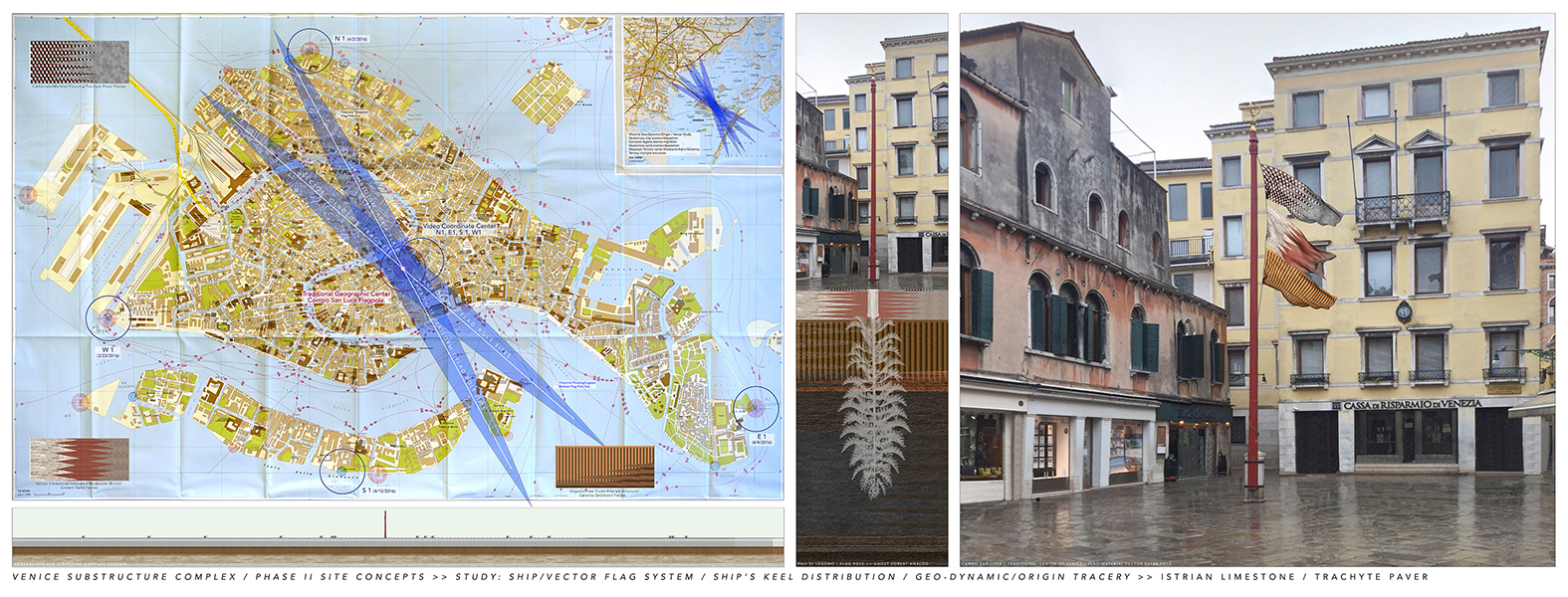
VENICE SUBSTRUCTURE COMPLEX / PHASE II SITE CONCEPTS >> STUDY: SHIP/VECTOR FLAG SYSTEM
The flags shown in VENICE SUBSTRUCTURE COMPLEX / PHASE II SITE CONCEPTS >> STUDY: SHIP/VECTOR FLAG SYSTEM.., represent the salient materials of the Venice Substructure Complex in different grouping corresponding to their primary arrangement within the Complex beneath Venice. The flags represent these materials/groups in general descending, stratigraphic order:
Carbonate (Marble) Flooring/Trachyte Paver Facies,
Istrian Limestone/Indurated Mudstone (Brick)/Cistern Sand Facies and
Organic Tree Trunk/Altered Alluvium/Caranto Sediment Facies.
Potential sites within Venice and the proximate lagoon area for temporary flag poles and flags appropriate to the substructure materials are distributed along the keel of each phantom Ship/Vector. The ship’s orientation is aligned with geologic and natural forces/vectors related to the origin of the flag materials. Each Ship/Vector is centered on the flagpole at Campo San Luca, traditionally known as the center of Venice. This central flag pole is interpreted as a theoretical/metaphorical “Euler Pole” of rotation, a mathematical device used in plate tectonics to understand plate movement on the spherical earth and representing an axis of natural process and material correlating the Anthropocene deposition of Venice Substructure Complex materials in historical time with the larger environment and generative processes in geologic time. |