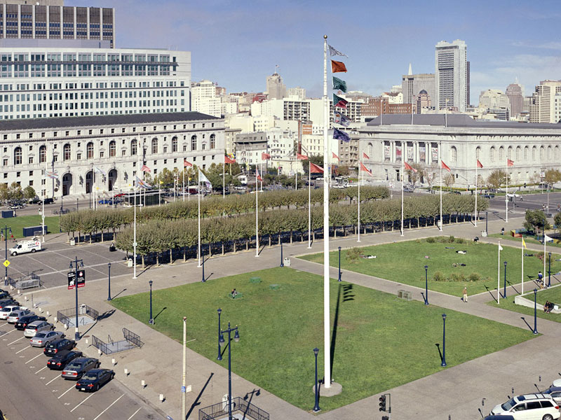
Protogaea Civica II (Franciscan Formation/San Francisco, CA)
The work, Protogaea Civica II (Franciscan Formation/San
Francisco, CA),
is the second and largest of three variations of the Geology
Flags Project,
a system of symbolic demarcation of site-specific geologic structures
and materials using flags. This version uses 19 flag poles at
the San Francisco Civic Center Plaza as part of the 2005 exhibition,
High
Five, presented in conjunction with the opening
of the new DeYoung Art Museum in Golden Gate Park, sponsored
by the International Center for the Arts at San Francisco State
University, in association with the San Francisco Arts Commission,
the San
Francisco Botanical Garden at Strybing Arboretum, and the de
Young Museum.
The flags used in Protogaea Civica II (Franciscan Formation/San
Francisco, CA), emblematically identify
the Civic Center’s site in relationship
to the Franciscan Formation, the bedrock beneath the larger Bay Area,
east of the San Andreas Fault. The Civic Center, in geologic terms,
rests unconformably (a time gap in deposition) on part of the Franciscan
called the Alcatraz Terrane, near its western edge. The Alcatraz
Terrane is a large block of primarily 135 million year old meta-greywacke,
a sub-greenschist-grade metamorphic marine sandstone1, accreted by
the process of plate tectonics onto the coast of Central California
forming part of what is know known as the Coast Ranges. This terrane
is bordered and underthrust to the west of the plaza by the Hunters
Point Shear (or Mélange) Zone, a shale matrix with suspended
blocks of other Franciscan rocks. The Alcatraz Terrane’s sandstone
and Hunters Point Mélange are represented by the flags on
the 18 central poles of the Civic Center Plaza. The large pole at
the corner of Polk and Grove Streets has a series of Index flags
representing materials of the larger Franciscan Formation including
architectural copper (the façade of the DeYoung Museum), contextualized
within this group as a Holocene Era constituent.
The complete set of flags of the Geology Flags Project are envisioned
as a comprehensive system of geo-taxonomy, an indexing and revealing
of the geologic materials and structures beneath any given site,
and, as flags flying above civic sites, such as the San Francisco
Civic Center, staking a claim for the “nationhood” of
nature and natural systems. The flags temporarily displaced at the
Civic Center, by Protogaea Civica II (Franciscan Formation/San
Francisco, CA), are political, national
and regional history flags. The geology flags refer to geologic history
and boundaries - cultural history
is temporarily displaced and re-articulated by nature. The Alcatraz
Terrane – Hunters Point Shear Zone boundary, indicated by the
flags, re-contextualizes normally perceived political boundaries.
The Franciscan Formation itself crosses the California-Oregon border,
similar accreted terranes are known along the west coast of the entire
western hemisphere, crossing many national and regional boundaries.
The full expression of the flag system would have a range from pure
chemical elements through mineralogy, paleontology, processes, materials,
formations, tectonic structures and architectural analogs present
above, beneath and/or extending from a site of study. The diagrams
on the flags are derived from geologic and architectural symbols
for materials and processes and can be used in different combinations
to describe any site with new flags for special or new attributes
being generated as needed. The ideal installation would involve numerous
flagpoles distributed throughout an extended site with appropriate
flags on each pole indicating the lateral changes in geologic information
below, like free-standing core samples. The architectural extension
of the geologic materials displayed as flags at appropriate sites
correlates the built environment and the contemporary Holocene era
with subterranean materials and time-frames. This idea refers to
the concept of anthroturbation,2 described in an essay written about
the work, Holocene Terrace,
shown at Lance Fung Gallery, NY, NY, 1999, an extract follows:
"
Cities, architecture, roads and other civic constructions made by
mankind of earth materials during our Epoch (the Holocene) may be
considered in a geologic context as forms of anthroturbation. This
term describes the disturbance, dislocation and restructuring of
geologic formations and materials by human agencies into new forms.
These processes have analogies in the natural world, such as: mining
as erosion, transport as flow and construction as sedimentation.
Likewise, the built topography of a city can be understood in geomorphic
terms: streets as canyons, buildings as plateaus, sewers as caves
and plazas as playas."
John Roloff, 2005
1. Wakabayashi, J., 1992, Nappes, Tectonics of Oblique Plate Convergence
and Metamorphic Evolution related to 140 Million Years of Continuous
Subduction, Franciscan Complex, California Journal of Geology, v.
100, p. 19-40., and in e-mail conversation.
2. This term was developed in conversation with the geophysicist,
Paul Spudich.
Installation
View North; Installation
View West: Installation
Detail: Anthroturbation
Flags; Flag
Details
Protogaea Civica I (Franciscan
Formation/San Francisco, CA) -
Topographies Exhibition, 2004;
Protogaea
Civica III (Santa Rosa) - Sonoma County Museum of Art, 2006
Selected/Recent Projects