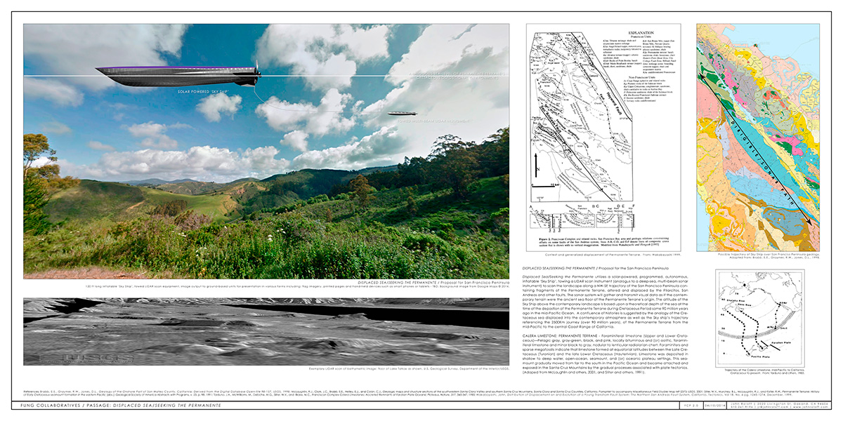
PASSAGE: DISPLACED SEA/SEEKING THE PERMANENTE / Proposal for the San Francisco Peninsula
Displaced Sea/Seeking the Permanente utilizes a solar-powered, programmed, autonomous, inflatable ‘Sky Ship’, towing a LIDAR scan instrument (analogus to a deep-sea, multi-beam sonar array) to scan the landscape along a NW-SE trajectory of the San Francisco Peninsula containing fragments of the Permanente Terrane, altered and displaced by the Pilarcitos, San Andreas and other faults. The sonar system will gather and transmit visual data as if the contemporary terrain were the ancient sea floor of the Permanente Terrane’s origin. The altitude of the Sky Ship above the contemporary landscape is based upon a theoretical depth of the sea at the time of the depostion of the Permanente Terrane during Cretaceous Period some 90 million years ago in the mid-Pacific Ocean. A confluence of histories is suggested by the analogy of the Cretaceous sea displaced into the contemporary atmosphere as well as the Sky ship’s trajectory referencing the 2500Km journey (over 90 million years), of the Permanente Terrane from the mid-Pacific to the central Coast Range of California. The sonar imagery is processed and output to ground-based recievers, cell phones, printouts, flags, murals, etc., for tracking of the sky ship and visualization of the landscape as a function of complex geologic and oceanic dynamics.
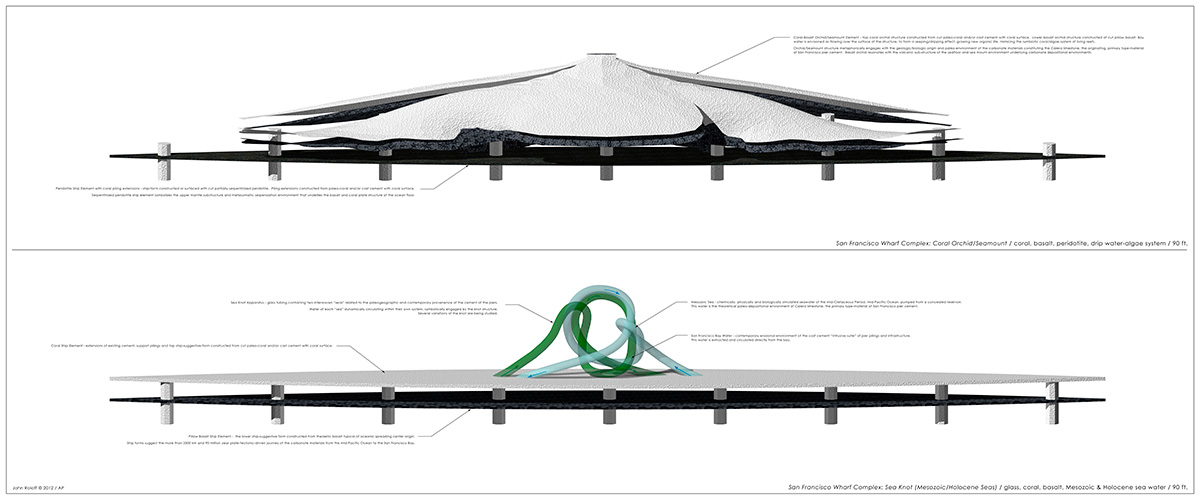
CALERA LIMESTONE: PERMANENTE TERRANE
Foraminiferal limestone (Upper and Lower Cretaceous)—Pelagic gray, gray-green, black, and pink, locally bituminous and (or) oolitic, foraminiferal limestone and minor black to gray, nodular to lenticular radiolarian chert. Foraminifers and sparse megafossils indicate that limestone formed at equatorial latitudes between the Late Cretaceous (Turonian) and the late Lower Cretaceous (Hauterivian). Limestone was deposited in shallow to deep water, open-ocean, seamount, and (or) oceanic plateau settings. This seamount gradually moved from far to the south in the Pacific Ocean and became attached and exposed in the Santa Cruz Mountains by the gradual processes associated with plate tectonics. (Adaped from McLaughlin and others, 2001, and Sliter and others, 1991).
References: Brabb, E.E., Graymer, R.W., Jones, D.L., Geology of the Onshore Part of San Mateo County, California: Derived from the Digital Database Open-file 98-137, USGS, 1998; McLaughlin, R.J., Clark, J.C., Brabb, E.E., Helley, E.J., and Colón, C.J., Geologic maps and structure sections of the southwestern Santa Clara Valley and southern Santa Cruz Mountains, Santa Clara and Santa Cruz Counties, California, Pamphlet to accompany Miscellaneous Field Studies Map MF-2373, USGS, 2001; Sliter, W.V., Murchey, B.L., McLaughlin, R.J., and Kistler, R.W., Permanente Terrane: History of Early Cretaceous seamount formation in the eastern Pacific [abs.]: Geological Society of America Abstracts with Programs, v. 23, p. 98. 1991; Tarduno, J.A., McWilliams, M., Debiche, M.G., Sliter, W.V., and Blake, M.C., Franciscan Complex Calera Limestones: Accreted Remnants of Farallon Plate Oceanic Plateaus, Nature, 317, 345-347, 1985; Wakabayashi, John, Distribution of Displacement on and Evolution of a Young Transfrom Fault System: The Northern San Andreas Fault System, California, Tectonics, Vol 18, No. 6 pg. 1245-1274, December, 1999. |