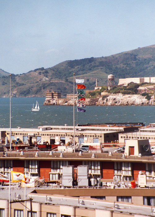
Protogaea
Civica I (Franciscan Formation/San Francisco, CA)
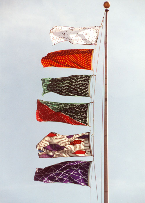
Six
flags, from The Geology Flags Project, depicting
the geologic materials and some structural relationships
of Holocene architecture and the major rock units of the
Mesozoic and Cenozoic Franciscan Formation, San Francisco,
CA; the top flag represents, reinforced concrete, a Holocene
Era formation.
These
flags, designed for the geology of San Francisco, focus on
the primary rock units of the Franciscan Formation, including:
meta-graywacke, radiolarian chert, serpentine, melange and
meta-basites as well as a Holocene architectural material
of the built environment, reinforced concrete. Commission
and installation of the Protogaea Civica I (Franciscan
Formation/San Francisco, CA) was done for the 'Topographies
Exhibition' at the San Francisco Art Institute, March 18
- May 8, 2004. curated by Karen Moss. Protogaea
Civica II (Franciscan Formation/San Francisco, CA), 2005
and Protogaea
Civica III (Santa Rosa), 2006, are more recent
works in this series.
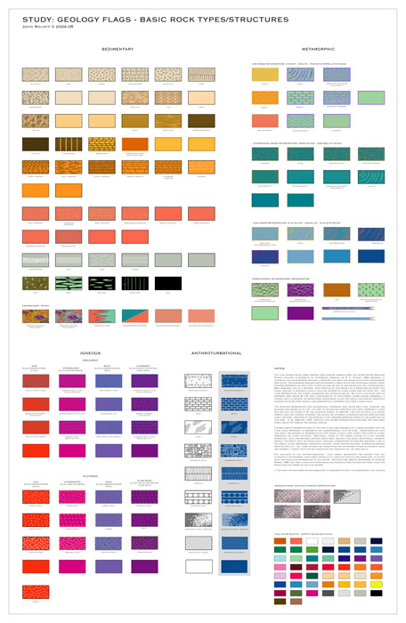
The
complete set of flags of the Geology Flags Project are
envisioned as a comprehensive system of geo-taxonomy, an
indexing and revealing of the geologic materials and structures
beneath any given site. The full expression of the flag system
would have a range from pure chemical elements through mineralogy,
paleontology, processes, materials, formations, tectonic
structures and architectural analogs present above, beneath
and/or extending from a site of study.
The
diagrams on the flags are derived from geologic and architectural
symbols for materials and processes and can be used in different
combinations to describe any site with new flags for special
or new attributes being generated as needed. The ideal installation
would involve numerous flagpoles distributed throughout an
extended site with appropriate flags on each pole indicating
the lateral changes in geologic information below, like free-standing
core samples. The architectural extension of the geologic
materials displayed as flags at appropriate sites correlates
the built environment and the contemporary Holocene era with
subterranean materials and time frames. This idea refers
to the concept of anthroturbation, described in an essay
written about the work, Holocene Terrace, shown at Lance
Fung Gallery, NY, NY, 1999, an extract follows:
" Cities,
architecture, roads and other civic constructions made by
mankind of earth materials during our Epoch (the Holocene)
may be considered in a geologic context as forms of "anthroturbation."1
This term describes the disturbance, dislocation and restructuring
of geologic formations and materials by human agencies into
new forms. These processes have analogies in the natural
world, such as: mining as erosion, transport as flow and
construction as sedimentation. Likewise, the built topography
of a city can be understood in geomorphic terms: streets
as canyons, buildings as plateaus, sewers as caves and plazas
as playas."
1 A term developed in conversation with the geophysicist, Paul Spudich.
|
NOTES:
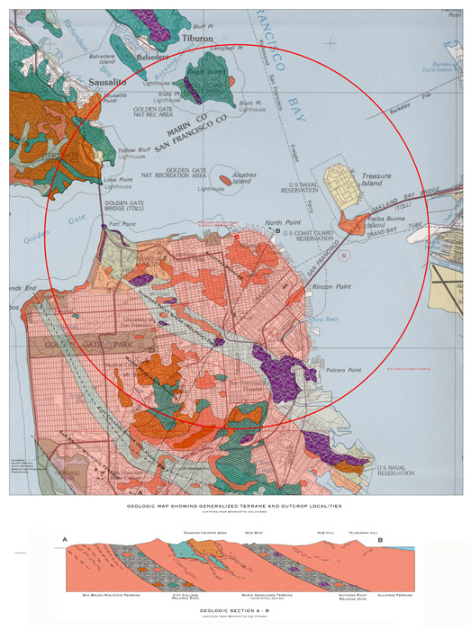
Study: Geology Flags Project/Franciscan Formation/San Francisco,
CA
The intention of the map and section is not geologic accuracy or authority but
to give an idea of the complexity and richness of the Franciscan Formation (also
known as the Franciscan Complex) and to relate the Geologic Flags to Bay Area
geology in a large area proximate to 555 Beach St, San Francisco, the location
of the flag pole where the flags have been installed (see map and images above)
for the Spring of 2004. The patterns used on the Flags and corresponding designs
indicating the rocks and structures on the map were derived from a larger geologic
indexing and identification system for nearly all rock types, see the drawing:
Study:
Geology Flags - Basic Rock Types/Structures, above. The anthroturbation
elements (human built architecture and structures) represented by the top most
flag (reinforced concrete) and recent (Quaternary) surficial deposits (primarily
soils, sands and alluvium) are not shown on the map for reasons of clarity as
most of the urban areas of map are covered by these materials.
Geologists understanding of the Bay Area geology and the Franciscan Complex has
evolved considerably since the acceptance of the theory of plate tectonics since
the 1960Õs and its role in the accretion and emplacement of marine sediments,
volcanics and crust that comprise the outer coast ranges of California.
It is now seen that the Franciscan Complex of the California Coast Ranges was
formed as a subduction complex related to east-dipping subduction along the western
North American plate margin from the Late Jurassic through the Early Tertiary,
this occurred over a period of at least 140 million years (Wakabayashi, 1992a).
The Franciscan is part of an 800 km long assemblage of similar rocks along the
west coast of North America. The main rocks of the Franciscan Complex are predominately
marine sedimentary rocks such as sandstone and shale with lesser amounts of marine
basaltic rocks and chert as well as serpentinite, a hydro thermally altered ultramafic
(low silica, high iron and magnesium) oceanic crust. Melange zones that
contain exotic blocks of other Franciscan rocks in a sheared shale or clay matrix
often separate more coherent thrust sheets. In regions that are not significantly
altered by Cenozoic deformation, Franciscan rock units, including melanges, comprise
a stack of nappes (terranes, e. g., Alcatraz Terrane) similar to structures that
are used to describe the European Alps (Seiders, 1991; Wakabayashi, 1992, 1999).
Apparent accretion ages of the nappes show them to be younger structurally downward,
which is a reverse of the normal depositional order of younger rock on top of
older rocks. This structure suggests emplacement as a result of progressive underplating
or offscraping in the subduction zone trench during the process of subduction
(Seiders, 1991; Wakabayashi, 1992). Some of the sedimentary (graywacke sandstone,
radiolarian cherts) and volcanics (basalts) have been metamorphosed by the heat
and pressure of subduction process, some at depths of 25 to 30 km, or more before
being revealed at the surface by uplift and erosion (Wakabayashi, 1999); meta-graywacke,
meta-cherts and meta-basites (greenstones) are the corresponding metamorphic
names. The active subduction process, which still continues north of the Mendocino
Triple Junction off the Mendocino coast to the north, ended in the Bay Area about
25 million years ago with the formation of the San Andreas fault (Konigsmark,
1998).
|
General
and Cited Professional References:
Alt, D. and Hyndman, D., 2000, Roadside Geology or Northern and Central California,Mountain Press, Missoula, MT.
Bailey, E., W. Irwin, D. Jones, 1964, Franciscan and Related Rocks, Bulletin
183, CA Division of Mines and Geology.
Elder, W., Geology of the Golden Gate Headlands, National Park Service, Golden
Gate National Recreation Area, PDF file: http://www.nps.gov/prsf/ geology/geoguide.pdf
Konigsmark, T., 1998, Geologic Trips, San Francisco and the Bay Area, GeoPress,
Guala, CA.
McPherson, G., Phipps, S. and Grossman, J., 1990, Diverse Sources for Igneous
Blocks in Franciscan Melanges, California Coast Ranges: Journal of Geology,
v. 98, p. 845-862.
Maruyama, S., Liou, J. and Seno, 1989, Possible Depth Limit of Underplating
by
a Seamount: Tectonophysics, v. 160, p. 327-339.
Pestrong, Raymond, Professor, Geology, San Francisco State University, e-mail
exchange.
Seiders, V., 1991, Conglomerate Stratigraphy and Tectonics in the Franciscan
Assemblage of Northern California and Implications for Cordilleran Tectonics:
U. S. Geological Survey Open File Report, OFR 91-50, 21 p.
Schlocker, J, 1974, Geology of the San Francisco North Quadrangle, California,
Geologic Survey Professional Paper, 782, Washington D.C.
Wahrhaftig, C., 1984, A Streetcar to Subduction, American Geophysical Union,
Washington, D.C.
Wakabayashi, J., 1992a, Nappes, Tectonics of Oblique Plate Convergence and
Metamorphic Evolution related to 140 Million Years of Continuous Subduction,
Franciscan Complex:
Californian Journal of Geology, v. 100, p. 19-40.
Wakabayashi, J., 1992b, Metamorphism and Tectonic Origin of Franciscan Metabasites
and a Field Trip Guide to Three Localities in the San Francisco Bay Area, in
Schiffman, P., D. Wagner, ed., Field Guide to the Geology and Metamorphism of
the Franciscan Complex and Western Metamorphic Belt of Northern California, California
Division of Mines and Geology, Special Publication 114.
Wakabayashi, J., 1999, The Franciscan Complex, San Francisco Bay Area: A
Record
of Subduction Complex Processes in Wagner, D., Graham, S., ed., Geologic
Field
Trips in Northern California, California Division of Mines and Geology, Special
Publication 119.
Maps:
The geologic map and section on this sheet were compiled and interpreted from
several different maps and related research:
California Division of Mines and Geology, Geologic Map of the San Francisco-San
Jose Quadrangle, California, 1:250,000, Map 5A, Regional Geologic Map series.
Wahrhaftig, C., A Streetcar to Subduction, American Geophysical Union, Washington,
D.C.,1984, several different maps and diagrams.
USGS Topographic Map, San Francisco Quadrangle, 1:100,000 series, 1978.
USGS Geologic Map of the San Francisco North Quadrangle, San Francisco and
Marin
Counties, California, Plate I, Professional Paper 782, 1974. |